
An in-depth documentary study of the story, unique in Italy, of a great city being built in an orderly and designed manner over a long period, beginning in the 17th century, with a severe and courtly Baroque imprint that continued into the next two centuries. An Atlasfor “documentation site” that remained suspended due to the exhaustion of the collaboration with the municipality.
The atlas documentation project was born as a result of the interest of the municipality of Turin: through the mapping and description of 61 points of interest, 2 urban routes, and 4 areas, the three Baroque-era urban extensions that occurred between the 17th and 18th centuries were illustrated. The combination of texts and archival images made it possible to document on Atlasfor the invention and construction of a capital city, following the transfer of the command center of the Savoy family from Chambéry to Turin.
The rich documentary material collected (the result of a months-long research, interrupted following the exhaustion of the collaboration with the local municipality) underscores the dominanate theme at the urban planning level in the period under review: combining a better fortification of the city (a need imposed by the development of war techniques) with the problem of urban expansion.
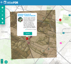
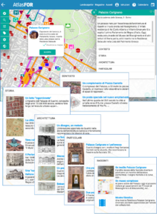
The interventions illustrated in the atlas (streets and squares, palaces and gardens, churches…) make it possible to clearly follow the ordering principle that sees the addition and formal integration to the pre-existing building fabric. In this regard, reference is made to two distinct modes of representation of points of interest on Atlasfor, a first concerning the Palazzina di Caccia di Stupinigi and its territorial scope, and a second relating to Palazzo Carignano.
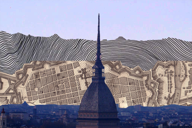
In the first case, the superimposition of the “Map of the Hunts” (1760-1766) on today’s map highlights the bearing of the Baroque design on the landscape: in fact, the roadways connecting the Savoy residence to the surrounding territory are still clearly visible. It is this interpretation of the landscape-a uniquely Piedmontese peculiarity and unparalleled in the world-that has enriched the territory, leaving an important widespread heritage, which Atlasfor is able to enhance in a unique and valuable way.
As can be seen in the second case, Atlasfor offers some substantial innovations compared to other proposals on the web of educational tool or atlas for tourists and inhabitants, providing the visitor with images, maps, videos that enhance the fascination of the place: with a kind of “augmented reality” in situ through the sources, until now never brought together and never seen: historical images of comparison “as it was/as it is”, frames of films shot on the place, projects, testimonies of events that happened. Thanks to the “around me” mode, you have a map and a list of what you can find around where you are: an invitation to serendipity open to the widest variety of cultural experiences, which can be selected with “filters” for themes or “keywords.”
The atlas thus makes it possible to illustrate in a way that is fully understandable even to those unfamiliar with Turin’s urban planning history the three Baroque extensions of the city.
The first extension starting in the 1720s concerns the area of the “new city” close to the pre-existing line of fortification along the axis of symbolic and functional connection between the suburban residence of Stupinigi and the Royal Palace.
Later between the 1940s and the 1950s the shape of what would be the geometric centerpiece of the expansion was defined-the first “Place Royal” in Turin, today’s Piazza San Carlo, built on the grounds of the defensive rampart beyond the fortifications following the French typological model designed by Carlo di Castellamonte.
In the 1970s, the shape of the second extension to the east toward the Po hinged on the oblique axis due to the presence of the bridge over the river on the site of the current Piazza Vittorio bridge with respect to the Royal Palace and connected to the hillside attestation of Cardinal Maurice’s villa, today’s Villa della Regina.
The third extension that concludes the urban expansion and consequently the elliptical ring of the fortified enclosure takes place in the first half of the eighteenth century westward in the direction of the erected and never completed suburban palace of Rivoli, along the axis of the contrada del Carmine present-day via del Carmine. This route is emphasized by the construction of the basilica of Superga – the work of Juvarra – considered the third allinaement apex of the rector axis.
Later, with the projects of Garove, Bertola and Juvarra himself, the radical transformation of the oldest building fabric in Porta palazzo was planned: this is the intervention that paved the way for the urban restructuring in the old city and was realized with the rectification of the road layout of the current Via Milano and the realization of the square of Porta palazzo through the restructuring of the contrada di Dora grossa (Via Garibaldi) and the alignment of the fronts on the street; as well as through the new arrangement of Via Palazzo di città on the route outlined already in the sixteenth century. These interventions became necessary because of the sharp increase in population, which in the late eighteenth century brought the resident population to 94,000 the city in fact after the Treaty of Utrecht in 1713 became the capital of the kingdom of Sicily.