
With this innovative research activity for school-work alternation in the humanities and communication disciplines, starting from the 2016-2017 s.y., it was proposed to the average students to tell about the city and the landscape through the use of Atlasfor. This offered students the opportunity to be not only the users but also the producers of part of the atlas with the coordination of their teachers and the accompaniment of the Association’s editorial staff. The theme for testing its effectiveness, agreed with MIBACT, was contexts related to the UNESCO Listed Assets: historic cities, the territorial areas of Palladian villas and royal residences, archaeological and Lombard sites, cultural and natural landscapes, such as the Dolomites, Cilento or the Wine Hills.
The project had the approval of the MIUR, with which an integrated promotion was set up with the MIBACT, for the choice of territorial references to be favored, year by year.
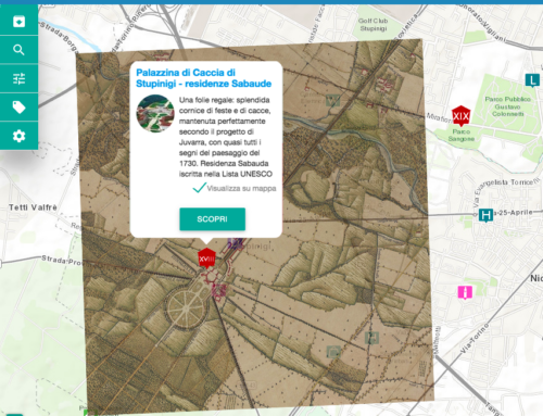
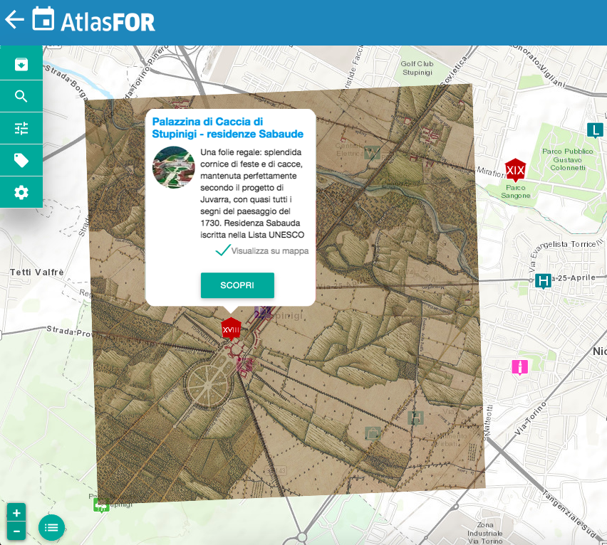
An initial experimentation was carried out in Turin, with 6 high school and vocational classes from two institutes, in the contexts of the Savoy Residences, a serial asset on the UNESCO lists. The points of interest that the students elaborated are represented in Atlas in the “Alternanza Scuola Lavoro” archive. The research that turned out to be of general interest was later published and made visible to all. These students became de facto editors of a part of the Atlas and thus acquired elements of a professional methodological approach to land research in the cultural-historical field, to the use of the IT tool and the web in the dissemination of iconographic and cartographic documents, to the communication and dissemination aspects in the development of texts and their version in different languages.
Operationally, students operated as follows:
the institutes, disciplinary departments or class councils concerned directly proposed or examined the Association’s proposals for activities to produce cards for points of interest, based on a list of topics and places provided by the Association itself, referring to context areas to UNESCO sites (in the expanded dimension mentioned above). The fact sheets provided for the collection of documentary material, referencing of sources, their arrangement in the form of a story in images, the provision of explanatory captions, the possible translation into foreign languages, and the technical processing of the images for posting on the web, with training and accompanying tutorials by the Landscapefor Association.
With this modality, the aspects of class school project and those of experimentation with school-work alternation, as per Law 107/2015, were combined, variously balanced according to the programs of the institutes or departments (in the Turin experiment for one school a 70-hour module was chosen, in one year, for the other, 150 developed over two years).
The teachers involved, in consultation with Landscapefor Association, defined the path and articulation of the project in detail and activated school-business co-design paths specifying in particular:
-the definition of the skills to be acquired through the alternation, referring to the educational objectives of the curriculum and the project;
-the operational articulation of the project: places, themes, time development, duration, sequences;
-the in-depth study of the profile of the learners, to specify any special learning opportunities or needs, with reference to the aspects outlined above;
-the tasks of the School and Landscapefor Association in the alternation training.
Teachers identified as mentors were trained with a short direct course to acquire the skills to manage a group of students in Atlasfor, which is made available to them for the necessary months;
Participating students were trained with an initial course (8/10 hours, also online) in the use of the database, georeferencing and Atlasfor-specific software, and how to write captions for documents.
Students worked in groups or individuals, at school or at home, referring to area libraries and other sources indicated by teachers and tutors;
A team of internal (teachers) and external (Ass.Landscapefor) tutors, organized in different ways according to the availability of each institute, carried out the accompaniment and monitoring of the training course and the skills acquired, drawing up in conclusion a report on the progress of the training activity as prescribed.
Tutors (internal or external) intervened online on the activities of the individual student, indicating corrections or solving difficulties that arose in itinere with remote forms of assistance.
Students were able to see the work of their peers and intervene: each feedback was recorded with date and name of the operator.
The elaborations developed by the group headed by one (or more) tutors were always visible to the entire group and, once finished, were submitted for “publication” in the Atlas, subject to validation by a scientific committee. At any time it was possible to download in .pdf format the elaborations produced.
Local libraries and, where possible, municipal governments, were involved to set up collection points for documentary material not available on the network, to which students should have access for reproductions and inclusion in the Atlas.
Twice during the course of the activities, a dedicated workshop was organized for mutual presentation of the work, with comparison between classes and illustration of the area and the areas investigated by each group (among different institutions in an area);
Any in-depth studies (e.g., introduction to Geographic Information Systems, multimedia content management, image scanning and processing, document archiving criteria) were handled on a case-by-case basis, according to specific needs.
The costs of participation, proportionate to the number of students and the services required, but in each case were traced back to the funds available for class offerings and school-to-work alternation.